This essay, written by Rice School of Architecture Gus Sessions Wortham Professor of Architecture Albert Pope, first appeared in print in Cite 97: The Future Now. Read the first part of this essay here.
Beyond the Corridor
Houston’s progress can be described as the transformation of a city organized by a single, dominant center, into a city organized by a number of dispersed and equivalent centers, to a city finally brought together by a banded/linear system that is rooted in the geometry of its most prominent natural features. In spite of its comprehensive geometry, Houston's centric pattern has never fully dominated the city. Since its founding, it has instead been driven by the give and take between this monocentric pattern, its polycentric buildout and the linear logic of its natural systems. This give and take will continue to determine the city’s subsequent growth with a marked shift in emphasis toward an accommodation of ever more volatile natural forces. This shift can be seen in transformations that are taking place in the city today, transformations that are nowhere more visible than in a remarkable new network that has recently been assembled under the name of Bayou Greenways 2020.
Bayou Greenways 2020 is an ambitious plan to unite the bayous within the city limits of Houston into a series of publicly accessible greenways. Adding 80 new miles to existing bayou parks, it will create a cumulative 150 miles of park space becoming the largest network of urban, off-street corridors in the country. (The second-largest system is Portland, Oregon with 78 miles.) In addition to the greenways themselves, 77 of Houston’s existing public parks exist along the axes of the corridors. Quoting from the Houston Parks Board’s introduction, “Bayou Greenways 2020 will create a network of connected, walkable nature parks and trails along nine of the bayous that run through every neighborhood within city limits. Upon completion, the project will add 1,500 acres of equitably distributed parkland, connect 150 miles of multi-use trails, and put 60 percent of all Houstonians within 1.5 miles of a public greenway.” To state what may already be obvious, Bayou Greenways embodies the banded/linear system that is rooted in the geometry of riverine network. It represents a significant reconciliation of an indifferent city to its natural systems. As such it is so much more than a “nature trail.” Given the environmental limitations which we confront today, it is the scaffold upon which the next iteration of Houston will be built.
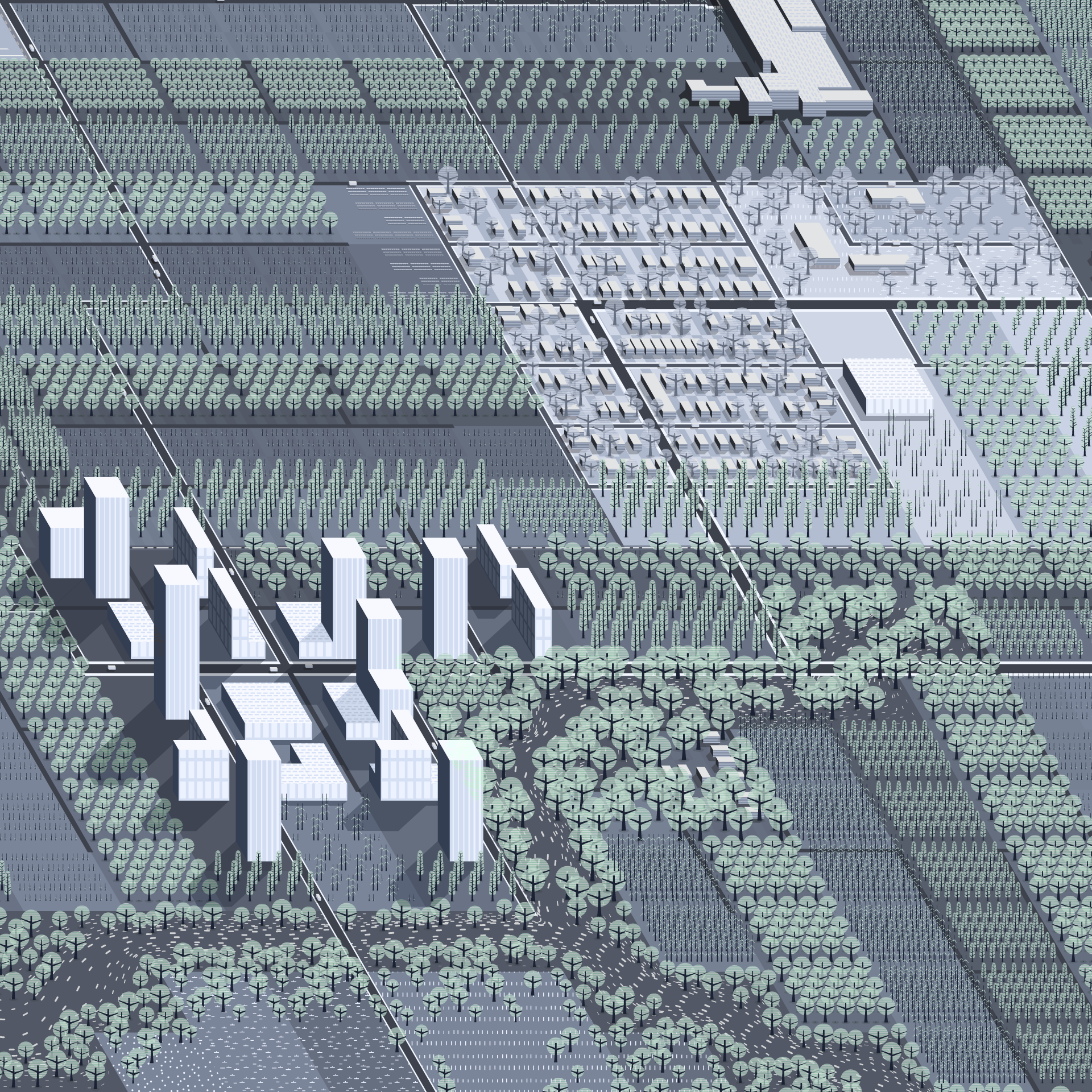 New Development, 2050, Buffalo Bayou at Japhet Creek. New high-density towers cluster around an existing tributary to Buffalo Bayou in the Fifth Ward. Diagram: Albert Pope.
There are many aspects of the network that could be used to support such a broad claim; I will emphasize two. First, the Greenways describe a new mode of urban connectivity that is unique to the suburban situation out of which they were born. The key fact in this claim is that the Greenways will “connect 150 miles of multi-use trails and put 60 percent of all Houstonians within 1.5 miles of a public greenway.” This statistic should give pause inasmuch as it suggests that the Greenways represent more than a new recreational amenity, but an entirely new mode of urban connectivity. For all that “walkability” has been the holy grail of recent urban debates, it often translates into another naive and unexamined call for the transformation of Houston into something resembling Brooklyn. The idea of using a traditional urban template on a city as dispersed and fragmented as Houston is simply a non-starter. Over 75 percent of the city lives on a discontinuous, spine-based urbanism of the cul-de-sac—an altogether different DNA than that of traditional, grid-based urbanism. Because these differences are structural, the likelihood that a city like Houston could ever be turned into a city with a street-life like Brooklyn is close to zero. This fact, however, need not lead the conclusion that Houston’s extensive freeway infrastructure has forever locked the city into an automotive transportation system. Given that 60 percent of the city’s population is now within a twenty-minute walk of an extended public corridor, this is clearly not the case. Reduce this twenty-minute walk to a ten-minute bike ride and the Greenways become an instant mass transit system for a post-carbon economy offering a level of connectivity that no city has, never mind a dissipated city like Houston. Without this low density and cheap land prices that accompany it the network could never have been assembled in the first place. As opposed to measuring the city against traditional modes of pedestrian accommodation, the greenways produce walkability in a distinctly new, sub-urban mode, a mode that is, incidentally, unknown to urban history.
Perhaps more important than the new mode of connectivity is the role that the Greenways will play in a new model of dense urban development. Already in Houston, urban density gravitates toward open space. While office towers tend to gather around freeway corridors, residential buildings tend to gather around open natural features, like the high-rise towers surrounding Hermann Park or Buffalo Bayou just west of Downtown. By “upzoning” Houston’s landuse regulations for the neighborhoods on either side of the greenways throughout the city, opportunities emerge for the creation of new high density development with greater height, more dwelling units, and the inestimable amenity of being directly adjacent to an urban, open space network. If Houston begins to build in a denser fashion, as it must to bring down per-capita energy consumption, a new model of urban density emerges from the Greenways. As opposed to piling up building mass in the manner of Manhattan or Hong Kong, this model could produce a distributed as opposed to concentrated build up of urban forms outside of the urban center. Tied together by the network of distributed open space that penetrates the entire extent of the city, new development is related, not to the limitations of the old concentric model of urban organization, but to the linear network.
In the end, the greatest benefit from moving toward a linear model of organization is that all natural systems are aligned to it. This reconciliation between natural and urban systems is ultimately what assures the city's success in an uncertain environmental future.
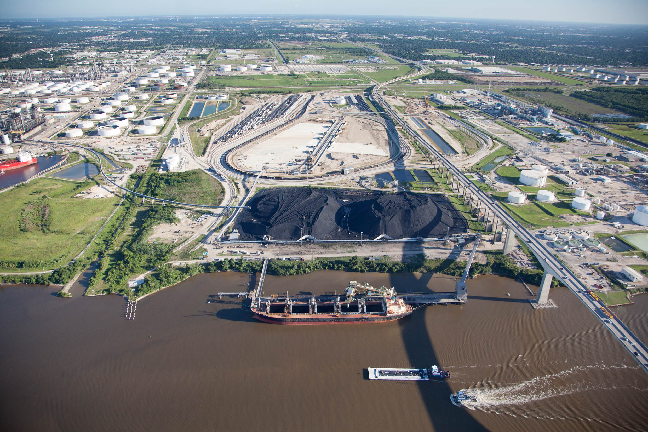 Two enormous piles of petroleum coke (petcoke), a byproduct of Shell's Deer Park Refinery, are visible. Photo: Alex MacLean.
Catalyst
“The challenge is to build for the future, not steal from it”
Edmund G. Brown Jr., Governor of California, Inaugural Address, January 5, 2015.
What catalyst would ever challenge the dominant concentric order of loop, beltway, and parkway? While the tangible evidence for climate change remains thin—a few hundred-year storms, melting glaciers, and increasingly sober scientific reports—the extraordinary stakes involved already require a vigorous response. Such a response should be automatic, requiring no more from us than a relatively modest leap of faith in the kind of science that we routinely trust. What this science tells us, however, is far from routine. It tells us that our actions have so profoundly transformed the planet as to both compromise our immediate future and cripple generations to come. Furthermore, it offers us outrageous limits like a required 80 percent reduction in per capita energy consumption by the year 2050. This reduction is based on the need to contain a rise in surface temperatures to 2 degrees Celsius—the agreed upon maximum that avoids severe food shortages, inundated coastal cities and massive displacements of population. The number is outrageous because, at this point (2014) 565 gigatons of CO2 is the remaining maximum carbon load the atmosphere can absorb and still limit warming to a 2 degree Celsius rise. At our present rate of emission it will take only 15 years until we reach this limit.
While it should be possible, if not also difficult, to respond to such numbers, one principal obstacle is daunting: the vast material infrastructure that encodes this high level of consumption into our way of life. These structures, which we call cities, represent nothing less than the accumulated wealth of the world. While to adapt, if not wholly reconstruct, this material infrastructure would seem the first line of response to the climate crisis, it has scarcely been put forth, even by those charged with its planning and construction. Beyond modest material interventions such as changing our light bulbs or shrinking our cars, the reform of our material environment seems almost unthinkable. It is easier to imagine absurd acts of geoengineering—seeding the stratosphere with light reflecting sulphur, growing carbon absorbing algae in the world’s oceans, or painting the Russian Steppes white—than it is to imagine reforming our cities. (Strange as it may seem today, however, such reforms are inevitable.)
This inevitability is based on a last number that has yet to be digested. According to the Fifth Assessment Report of the UN-sponsored Intergovernmental Panel on Climate Change (IPCC), urban areas account for between 71 and 76 percent of CO2 emissions from global final energy use. Inasmuch as cities count for two-thirds of the world's overall energy consumption they constitute a single, unified front on the war against climate change. In other words, no matter what route the response to climate change takes, it must go through our cities and address the patterns of high energy consumption that they presently require. If this is not quite apparent today, it will be in the near future. The IPCC’s Report described the outsized role that urbanization will play in the climate crisis over the coming decades:
the scale and speed of urbanization is unprecedented: more than half of the world population live in urban areas and each week the global urban population increases by 1.3 million. Today there are nearly 1000 urban agglomerations with populations of 500,000 or greater; by 2050, the global urban population is expected to increase by between 2.5 to 3 billion, corresponding to 64 percent to 69 percent of the world population. Expansion of urban areas is on average twice as fast as urban population growth, and the expected increase in urban land cover during the first three decades of the 21st century will be greater than the cumulative urban expansion in all of human history.
What the report tells us is that the frontier of climate change is not in the stratosphere, the oceans, or even the poles, it is the cities in which we live and the habits of consumption that are built into them. This is nowhere more true than it is in Houston. Where there once was no limit to the amount of energy we could produce and consume, we are now moving into a period in which such limits are likely to touch almost every enterprise that we undertake. Historically, Houston’s negotiations between its natural and urban systems were based on how much energy we could produce; in the very near future, those negotiations will be based on how much energy we consume.