The article below by Jim Blackburn was original published in 2014 as part of a special issue on environmental challenges to the Houston region.
The future of the City of Houston might be more affected by extreme weather events than by any other factor. The impacts of these extremes are well known but not well addressed. Our ability to compete and survive in the harsh natural environment and competitive economic climate of the 21st century will rest on how we address these challenges.
As we learned in 2011, drought is a serious worry. Though we should plan for and anticipate constricted water supply and availability, we are not as vulnerable as many other areas of Texas. Our Achilles heel is flooding.
Flooding in our part of the world comes from two major sources: major rainstorms associated with tropical storms or cold fronts, and the surge tide associated with hurricanes. These two sources of water---one coming from the sky and the other from the Gulf---are major threats to our well-being.
 Click to enlarge.
Houston will be severely and perhaps permanently affected if we don’t address our known problems. All of the issues discussed below have solutions, but these solutions require that action be taken—that things be done differently. Some of the incentive for these changes will have to come through litigation simply because responsible officials will not otherwise step up and do what needs to be done.
STORM SIZE AND PROBABILITY
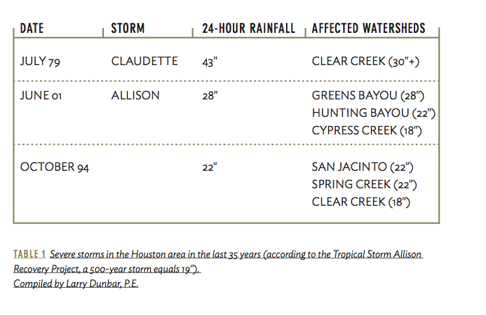
A key issue that has prevented effective planning and response to flooding has been our denial about the size of storms that can or should be anticipated. The 100-year recurrence rainfall standard used for most federal flood insurance maps is 12 or 13 inches in 24 hours, depending upon where one is located within Harris County. However, several rainstorms in the last 30 years have exceeded 20 inches in 24 hours, including tropical storms Claudette and Allison. At different places in Harris Country, we have also seen multiple smaller rainfalls dump more than 13 inches in 24 hours (Table 1). No wonder we hear all the time that we have just experienced a 100-year rainfall. The 100-year rainfall we are using is essentially meaningless from a property protection and integrity standpoint.
 Click to enlarge.
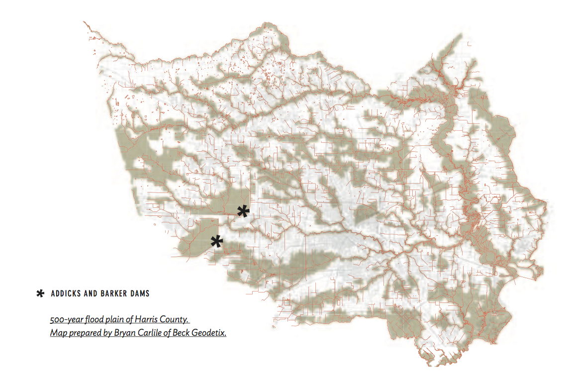
If you are moving to Houston from another part of the United States or the world, you would be much better advised to use the 500-year flood plain based upon 19 inches of rain in 24 hours as a reasonable worst-case flood prospect, rather than the regulatory 100-year flood plain. If we relied upon the 500-year flood plain as a standard, over 400,000 acres would be identified as a hazard zone, representing 38 percent of Harris County.
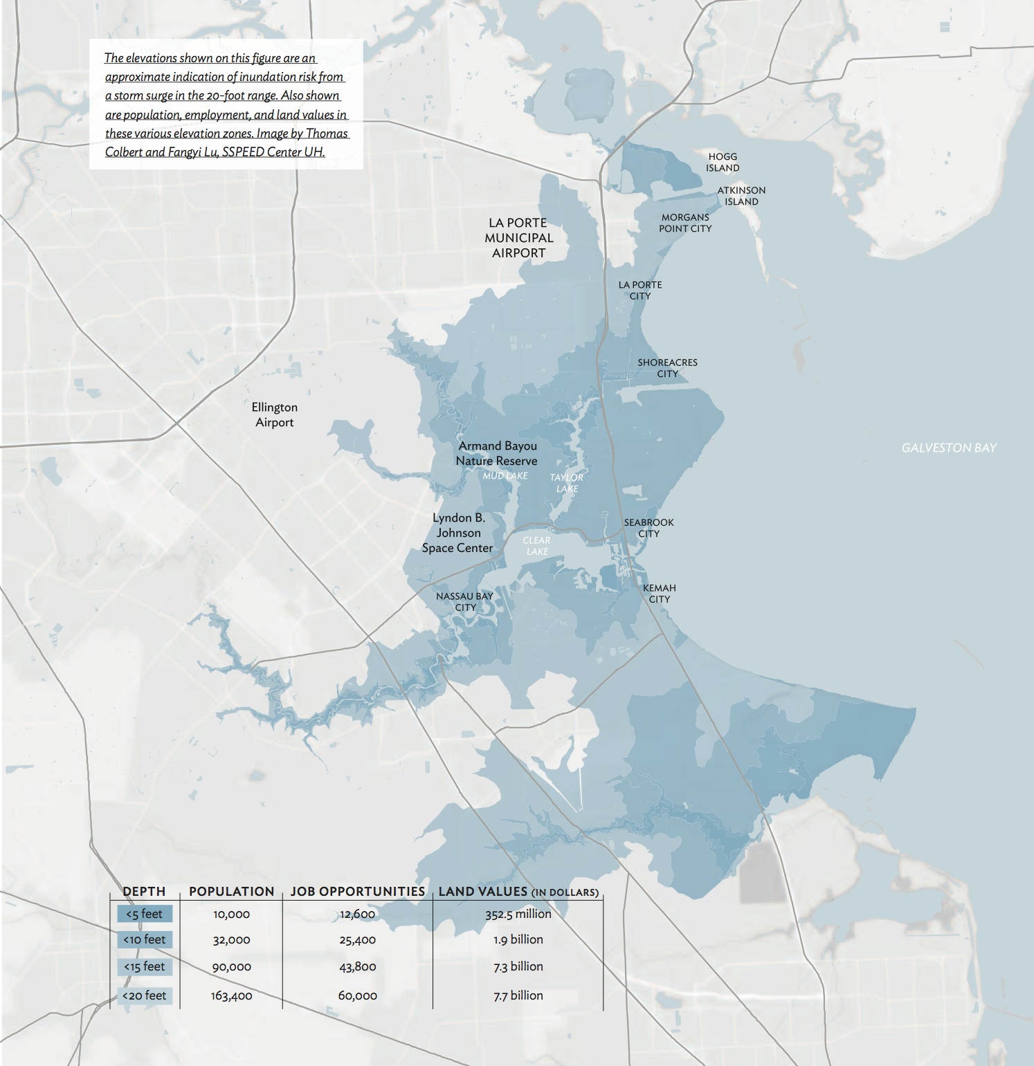
The same lack of realistic information distorts assessments of hurricane surge tide risk. Most existing flood plain maps do not show the extent of flooding that would be expected from a reasonable worst-case hurricane. Hal Needham of Louisiana State University has estimated—based on historic storms—that those living on the upper Texas coast fall into a very high risk zone, with a 100-year hurricane surge estimated to reach about 20 feet above sea level from where the coastline meets the Gulf of Mexico. Due to the magnifying effects of bays, a 20-foot surge at the coast could trans- late into a 23- to 25-foot surge in the upper part of Galveston Bay and the Houston Ship Channel, depending upon exact point of landfall. A 20-foot surge event on the Clear Lake area of Harris County would lead to depths of inundation reaching 10-12 feet across much of the developed area.
Recently, the Federal Emergency Management Agency (FEMA) released new 100-year flood plain maps for many of our coastal communities in Harris County, such as LaPorte, Shoreacres, and Seabrook. These maps show a proposed 100-year surge elevation of approximately 17 feet, rather than the 20 feet that might be expected from Needham’s 100-year projection, which is based upon the 1900 Galveston hurricane.
It is worth pausing a moment to reflect on the relationship of Houston and Harris County with the National Flood Insurance Program. Many Houstonians decry the federal government in their political rhetoric, but our collective hands are out when we experience a major flood. We receive federal disaster relief, and until recently, those with flood damage have benefited from federally subsidized flood insurance payments. However, the Biggert-Waters Flood Insurance Reform Act of 2012 requires that flood insurance premiums be based upon risk, meaning that previously subsidized insurance rates will be increasing substantially for those within the 100-year flood plain. As we get the flood plains more correctly defined and move to an actuarial basis for flood insurance, we will see a major correction in the signals that the market sends about flood risk.
Insurance in riskier sites should be more expensive. We should support “full-cost pricing” of flood insurance and let the market begin to play a role in our handling of flooding issues. Many Houstonians state that they believe in the market system, so let’s put our policies where our rhetoric is. That would be a good start to honestly addressing our problems.
CURRENT PROBLEM AREAS
The Houston region has many flood problems and many potential solutions. But in order to address them, we need to be honest about the risk and take collective action before we are dealt a blow from which recovery will be difficult, if not impossible.
 Click to enlarge.
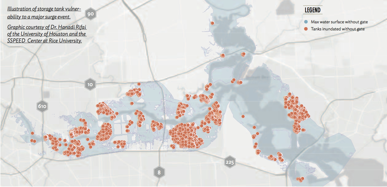
Houston Ship Channel
Consider the Houston Ship Channel. The 20 miles or so between Loop 610 East and the State Highway 146 Fred Hartman Bridges crossing the channel contain one of most concentrated refining and chemical plant agglomerations in the world. This Ship Channel industrial complex generates over 140,000 direct and indirect jobs, represents a capital investment of around $60 billion, and is the economic engine of the Houston region if not the United States. If this complex were to be crippled by a major storm, all citizens of our region and of the larger nation would feel the economic impact.
So how vulnerable is the Ship Channel complex? Generally speaking, the facilities along the Ship Channel are not protected from flooding beyond the currently mapped flood plain elevation of about 14 to 15 feet. Work completed at the SSPEED Center at Rice University modeled a reasonable worst-case storm as generating a surge of approximately 25 feet. This storm would inundate portions of over 100 facilities and would represent a direct threat to about 1,400 storage tanks of various sizes that line the channel.
If such a surge were to occur, it would likely generate one of the worst environmental disasters ever experienced in the United States. A single tank that was lifted off its foundations during Hurricane Katrina caused a major evacuation and buyout. Galveston Bay would suffer major ecological damage and would likely become a hazardous materials disaster zone. The ecological damage easily could lead to curtailment of recreational and commercial fishing as well as signaling the end of bay-oriented development.
 Click to enlarge.
The economic damage would be even greater. When the Invista plant in Orange, Texas, was flooded by Hurricane Ike in 2008, it was shut down for months. The flooding projected along the channel would be much more severe than that which struck Invista and could lead to damages so substantial that reconstruction might not occur for years if ever. Overnight, our economic engine could be extinguished along with the ecological health of Galveston Bay.
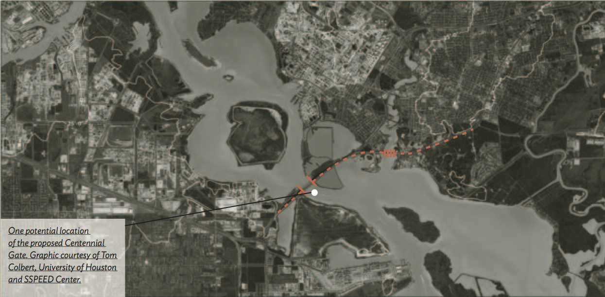
This disaster can be averted by pursuing a relatively straightforward solution. High ground exists on both sides of the Ship Channel near the Fred Hartman Bridge. Preliminary engineering evaluations indicate that it should be possible to build a levee and gate structure that the SSPEED Center calls the “Centennial Gate.” This gate could span the Ship Channel and protect inland assets, including Houston residential areas along with refineries and chemical plants, for a cost of about $2 billion. Such a project could be designed by local engineering firms, permitted by the U.S. Army Corps of Engineers, and financed by creative local bond funding, with scheduled completion in less than five years once the decision to proceed is made. We should make this commitment as soon as possible. [Learn about the SSPEED Center's proposed Houston-Galveston Area Protection System.]
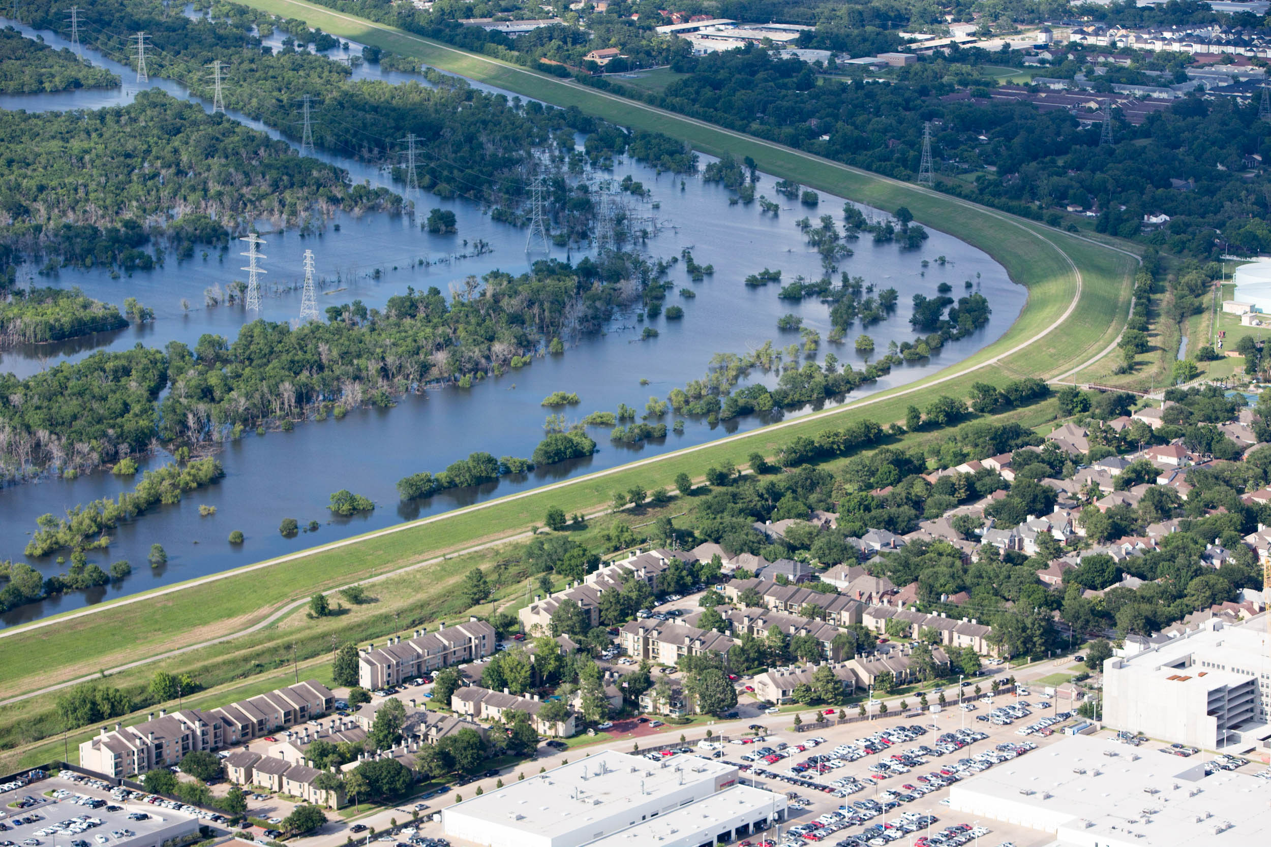 Addicks Reservoir. Photo Alex MacLean.
Addicks and Barker Reservoirs
The Addicks and Barker Reservoirs lie on either side of Interstate 10 West. Addicks is on the north, and Barker is on the south; Highway 6 runs just east of Barker and through the west side of Addicks. These huge detention ponds were built for flood control in the late 1940s and early 1950s toprotect Downtown Houston and Buffalo Bayou neighborhoods from flooding. Without doubt, these are the best flood control projects ever built in Houston, but they are currently in danger of failing and now represent a major risk to those living along Buffalo Bayou.
Documents released by the U.S. Army Corps of Engineers, the agency responsible for constructing and maintaining Addicks and Barker Reservoirs, rate them today as being at risk for “catastrophic failure.” This potential failure is due to voids within the levees that make them susceptible to collapse. If either of these dams were to collapse after the reservoirs have been filled with rainfall from one of our huge rainstorms, a flood of Biblical proportions would spread throughout much of the energy corridor and the Memorial Drive area, extending all the way Downtown.
The Corps is aware of this problem and is taking both short-term and long-term measures to address it. However, we as a community have failed to recognize the implications of these “fixes” or the reality of the amount of time that will be required to remedy these problems.
Though the situation with Addicks and Barker is complicated, suffice it to say that the Corps is worried enough about the potential for dam failure that they have changed the operational plans for the reservoirs to allow much more water to be released. Essentially, until these reservoirs are repaired, we no longer have the full capacity of Addicks and Barker available, meaning that all of those living downstream are at much greater risk than was the case ten years ago. Yet our local flood control district and various elected officials are acting as if this serious situation does not exist.
Recently, Federal District Judge Keith Ellison ruled in favor of the Sierra Club in a suit brought in Houston federal court arguing that the Corps of Engineers had to fully disclose the impacts of development in the Katy Prairie upon the operations of Addicks and Barker Reservoirs. Although Judge Ellison chose not to enjoin construction of the Grand Parkway, he ruled that the development in Harris County west of the Addicks Reservoir had a “cumulative” effect on Addicks and must be fully understood and disclosed by the Corps in environmental assessment documentation.
Another major problem in west Harris County is the action (or inaction) of Harris County and the Harris County Flood Control District (HCFCD). The rules of the HCFCD require detention ponding, but specify that it be able to hold only the storm water accumulated in 24 hours. Addicks is designed to hold the rainfall from huge storms occurring over multiple days, and detention ponding is not enough to supplement it as flood protection. In fact, one potential conclusion of the Corps’s environmental assessment may be that current Harris County policy will worsen the existing operational problems of Addicks Reservoir.
Here, the solution is simple. The Katy Prairie when left undeveloped is a wonderful sponge full of natural wetlands. Consistent with an economic view of the natural system and the risk of its development, we should—as a community—consider paying landowners to maintain these prairie wetlands. They are worth more to us in holding floodwaters than they are as sites for development. We are not limited in land for new development. We are, however, limited in our options to protect the Addicks and Barker Reservoirs, and downstream.
INCREASING FLOOD PLAINS, BUYOUTS, AND LITIGATION
The flood plains of many of our bayous and creeks have grown substantially over the last two decades. Over that period of time, more than 35,000 acres that previously were not shown to be in the 100-year flood plain have been added to that danger zone. Many homes that were built outside the 100-year flood plain in reliance on those flood plain maps are now shown to, and in many cases actually do, flood.
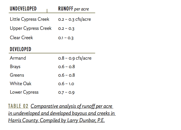
The problem of Houston’s growing flood plains has been known for decades, largely based upon the seminal work of Don Van Sickle and Dr. Phil Bedient on Brays Bayou. Channelized in the 1950s to accommodate a 200-year storm and widened over the last decade at a $450 million cost, Brays Bayou today can barely hold the rainfall of a 10-year storm. Our failure to address the problem of development impacts upon our bayous can be seen in the analysis of runoff per acre from undeveloped and developed watersheds (See Table 2).
This comparison is important. It shows that as land in Harris County has been developed, storm water runoff per acre has increased. Our natural landscape is flat and interspersed with wetlands that can hold significant volumes of rainwater. Developed areas, however, are full of concrete, sloped yards, and highly efficient storm sewers and drainage ditches that push the water off of the areas. And we push it downstream.
Interestingly, the development requirements of the HCFCD allow 1-2 cubic feet per second (cfs) of storm water to be released per developed acre after the use of detention ponding. This is almost 10 times greater than natural runoff rates. One might reasonably ask: “What kind of regulation is this?” The answer is: “Houston-style regulation.” A pond is required, but it is not nearly large enough to do the job of reducing development impacts. As such, we are reducing development costs but increasing downstream damages and flood insurance payments while also reducing downstream property values.
The bottom line is that our flood plains are growing, as discussed earlier, and these expanding flood plains translate into huge flood damages. Over the last two decades, the city of Houston and Harris County have been among the largest claimants of recurrent flood insurance payments in the country. Over that time, both the federal government and the Flood Control District have decided that the buyout of homes experiencing recurring flood damages makes more financial sense than allowing them to continue flooding and continue making flood insurance claims.
To date, it is difficult to get an accounting of the total number of homes that have been bought out, but several hundred homes have been bought out on White Oak, Greens, and Brays Bayous. This is understandable, given the significant home flooding that exists along these bayous and the predictability of this result.
As a community, perhaps we should look at buyouts more strategically. We know of many areas that we can predict are going to flood again and again—it is just a question of when. We should become much more proactive with regard to setting aside monies for buyouts and make acquisition of flood-prone homes a major aspect of our flood planning.
Houston can become resilient in the face of flooding, but it will require removing homes and re-establishing flood plains and green space. Eventually, Houston and Harris County might end up with a bayou green space system acquired by repurchasing homes. It is expensive. Regulation would have been cheaper. But on a cosmic level, such a result seems like a perfectly “Houston” concept given our disdain for effective regulation and our affinity for development.
 Click to enlarge.
On the other hand, many choose to characterize this increase in the delineation of flood plains as either a “taking” or “damaging” of private property in violation of the 14th Amendment of the U.S. Constitution as well as the Texas Constitution; others view it as an illegal seizure in violation of the Fourth Amendment. The Texas constitutional issues regarding damaging and taking of private property due to downstream flooding impacts from Harris County policies and actions have been raised in a case involving flooding on White Oak Bayou that has just been briefed to the Texas Supreme Court. There has also been investigation of similar litigation due to flooding adjacent to TIRZ 17 and Memorial City in West Houston as well as other areas. It is worth noting that under the litigation scenario, compensation might be required by the court without a buyout, making the buyout alternative seem all the more reasonable.
CLEAR LAKE AND SURGE FLOODING
The Clear Lake area is incredibly vulnerable to hurricane storm surge flooding. Here, the major problem is faulty information in the flood plain maps.
The flood plain maps currently in effect do not give any warning to a potential buyer of the extent of potential surge flooding. Only now are these maps being revised to include surge flood elevations, and the proposed maps stop short of indicating a reasonable worst-case surge event.
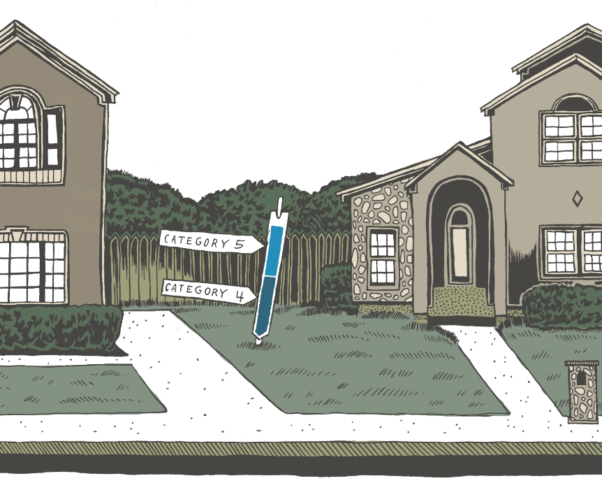
Harris County Precinct 2 attempted to give such warning to residents of the Clear Lake area by placing signs at intersections showing the extent of surge flooding that could be expected from a Category 4 and a Category 5 storm (as depicted in the opening illustration). This excellent informational device was immediately attacked by real estate agents and developers, however, and the signs were removed due to public outcry. This example is a sad but true commentary on our priorities as a community. We need to get better information to our citizens, particularly those moving into our coastal area from the Midwest, for example, with little experience in hurricanes and storm surge.
In our society, we seem to endlessly debate the role of government. It would seem that an obvious role of government would be to make high-quality, accurate information available to help people make smart market transactions. It seems negligent for government to stand by doing nothing while people are moving into a hazard zone from which they might not be able to escape under certain flooding situations, yet that is exactly what is happening in southeastern Harris County today.
The risk for those buying homes or living in the low-lying areas is twofold – the actual surge hazard in terms of property damage and the inability to evacuate to a safe location. Today, approximately 1.5 million persons live in the hurricane evacuation zones in Chambers, Harris, Galveston, and Matagorda Counties. The Houston-Galveston Area Council (HGAC) has projected that another 800,000 persons will move into these low-lying areas by 2035. HGAC has also projected that we could evacuate only about 1 million people in 36 hours from these areas under perfect conditions.
These facts show that we are heading for an unprecedented disaster in the developed low-lying portions of the coast. Landowners have a right to develop. However, they do not have a right to raid the public treasury, nor do they have the right to place innocent homebuyers into harm’s way without information. As a community, we know that this situation exists, but we do nothing about it.
 Click to enlarge.
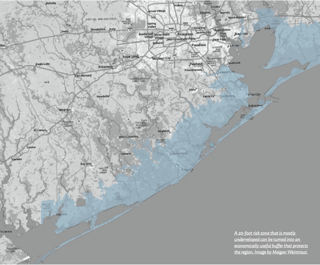
BUFFER ZONES AND AN ECONOMY FOR THE FUTURE
Much of the low-lying land in Chambers, Galveston, Brazoria, and Matagorda counties is not currently developed. Of the million acres below the 20-foot contour line along the coast in these four counties, over 200,000 are currently preserved as part of the National Wildlife Refuge System, as Texas state parks or wildlife management areas, county parks, or holdings of non-governmental organization land. Much of the remaining acreage is owned by private ranchers and farmers.
These low-lying lands serve a tremendous function in our region by absorbing storm surge and storing it, releasing it back over many days. Most importantly, these highly productive ecological systems are not destroyed by flooding. Instead, their structure and function allows them to survive inundation. They are absolutely resilient.
At the SSPEED Center at Rice, we have been working on ways to conceptualize and implement an economy that mimics the resilience of this natural system. Better yet, we are trying to structure an economy that is based on these resilient ecosystems. The prospects are exciting.
One idea is to capitalize on the natural value of these low-lying lands through better access and ecotourism. To this end, the creation of the Lone Star Coastal National Recreation Area as a unit of the National Park System has been proposed. This idea is currently being championed by Houston businessman John Nau, former Secretary of State James Baker, and the National Parks Conservation Association. Various committees have been formed to support this concept, which may reach Congress in the near future.
A second idea is to create a system within which to buy and sell the “innate value” of our coastal wetlands, prairies, and forests. The fact that natural systems have innate values that can be measured in dollar benefits to society has been discussed for years. Nevertheless, these discussions have largely been theoretical, and landowners have seldom been able to realize a dollar value for preserving and nurturing natural ecosystems.
That problem may be on the brink of a solution. As sustainability becomes a larger part of its public image, corporate America is becoming more and more concerned about “footprints” of different types, including carbon, water, and ecological footprints. Many of these corporations are now spending money to offset their footprint, buying the rights to natural systems or values from natural systems, rather than the land itself.
At the SSPEED Center, we are proposing to create an ecological services exchange across the low-lying areas of the four coastal counties to connect a willing buyer with a willing seller in transactions involving natural ecological services. In this manner, our farmers and ranchers could be paid for restoring prairies, coastal marshes, and forests as carbon sinks or for other value these restorations provide.
We know that these areas will flood sooner or later. If we have developed an economic system that can survive inundation, we will be far ahead.
CONCLUSION
As a community, we have failed so far to take on the hard issues of flooding. If this attitude does not change and if we do not find acceptable means to address these problems in creative ways, then Houston’s future will remain under a cloud.