This article by Eric Leshinsky is an updated excerpt from an article that appeared in Cite 99, "Designed to Flood: Urban Design in the Age of Unrelenting Floods."
The prevailing story in Houston is that not enough is being done to mitigate flooding. It’s hard to argue with that, given the rising impacts from flooding, the city’s long-standing culture of privileging growth at all costs, and our historical unwillingness to steer that growth in any way that would reduce the risk of flooding. But there’s another story that tends to get lost in the conversation that follows every devastating storm. What if the problem isn’t that we have done too little to manage floods, but that we have not been smart about it? Recently, with little fanfare, one of Houston’s most significant efforts to manage flooding has reached a major milestone. Conceived nearly twenty years ago, Willow Waterhole Stormwater Detention Basin is now beginning work on its final phase of construction. In this article, I look at this example of a big, smart approach to flood management that shows what we have done right and what we can do more of.
For those who have never visited the sprawling site in southwest Houston, Willow Waterhole is actually a network of six interconnected basins — essentially massive manmade lakes designed to hold nearly 608 million gallons of stormwater that might otherwise wreak havoc on surrounding homes and businesses. Significantly, the basins are also designed to serve purposes well beyond drainage: an expansive urban park ranking as one of the largest in Houston; over 200 acres of new or enhanced wildlife habitat; miles of trails; the site for numerous community and citywide events throughout the year; and a dramatic change of scenery in what is otherwise an ordinary Houston landscape of strip malls, industrial facilities, residential subdivisions, and vacant land. Although it was the long-term duration of the project that made news recently, the sheer size and vision of the Willow Waterhole complex would be newsworthy enough.
 Westbury Cross Country Classic race and fun run. Courtesy Willow Waterhole Greenspace Conservancy.
The recent Willow Waterhole milestone is significant for several reasons. The milestone comes at a time when Houston is experiencing a greater frequency of flooding than ever in its history. It culminates what has become one of the region’s best examples of drainage infrastructure that doubles as an urban amenity, and perhaps most critically, it renders visible just how much the landscape of Houston needs to be altered to properly mitigate the flood waters it regularly receives and will continue to receive for the foreseeable future. How we choose to make these alterations is ultimately a design decision that holds enormous consequences for the city and for us, it’s inhabitants: how will a city designed to better manage flood waters impact our daily lives? Can it actually improve our lives beyond the basic necessity of keeping water out of our homes?
Navigating South Willow Drive, a small side street that connects South Post Oak to Chimney Rock, you’d never expect to see the massive lakes that constitute the Willow Waterhole Stormwater Detention Basin. But as you walk around the various lakes which comprise the basin, it’s ok to suspend your disbelief. Nearly twenty years in development by the Harris County Flood Control District, the lakes feel woven into the urban fabric of the area, as if they’ve become an honorary part of the area’s native landscape. Now managed jointly with the Houston Parks and Recreation Department and the Willow Waterhole Greenspace Conservancy, the network of parks, trails, and habitat areas is less dramatic than Barker and Addicks Reservoirs but still one of the best examples of drainage infrastructure as a community commons. Additionally, plans for Levitt Pavilion, to be completed by 2020, were announced, which could help elevate Willow Waterhole to the level of a signature park that stitches the neighborhoods around it — an example of flood management as urban design.
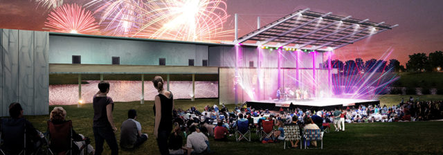 Photo: Courtesy of The Levitt Foundation.
The recent announcement of the basin’s final phase of construction puts into perspective just how much the project has evolved since it was first conceived in the late 1990’s.It was actually in the 1980s when a variety of circumstances set in motion a policy shift that would have a catalytic impact not only on how landscape changes in the interest of flood control could be deployed across Houston, but also on their relationship to surrounding communities. Pivotal was the effort started in the late 1960s by late environmental activist Terry Hershey, the nascent Buffalo Bayou Preservation Association (now Bayou Preservation Association), and an unlikely comrade-in-arms in then U.S. Rep. George H.W. Bush that saved Buffalo Bayou from being reshaped in concrete. But the later creation of Terry Hershey Park along Buffalo Bayou in 1989 had more to do with the intensifying demand for more parks, trails, and general recreation opportunities in Houston’s expanding west side. After state legislative action provided a new allowance for trails along flood control easements, and Congress passed the 1986 Water Resources Development Act, which enabled the Army Corps to work with local partners on flood control projects, community input became an integral component of major infrastructure projects.
The 1990 Sims Bayou Federal Flood Damage Reduction Project stands as the first effort to treat flood channel improvements along a bayou as more than infrastructure by also creating a greenway amenity for surrounding communities. Many of the bayou enhancements we now consider commonplace — planted banks and paved trails, interpretive signage and seating areas, preserved or restored habitat areas, and destination parks sited strategically at stormwater detention basins along the trails — were first tested on Sims Bayou.
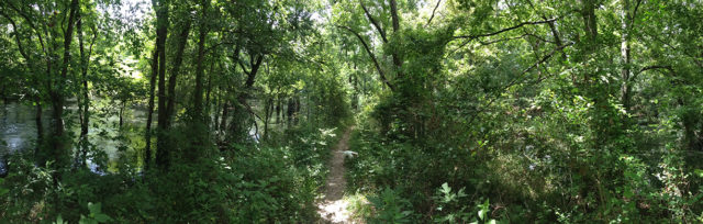 Photo: Eric Leshinsky.
But it was the drainage policy and design proposals of former HCFCD director James B. Green that had the most transformative impact during those years. His letter to the Harris County Commissioners Court holds the seed for much of the landscape infrastructure that defines Houston today. Detention basins were once seen as an untested idea that could have unintended consequences, offering at best a temporary fix, but the straightforwardness of the concept — undeveloped tracts of land are purchased, excavated into deep craters with inflow and outflow channels, and intentionally flooded with overflow from bayous and other tributaries during peak storm events — proved to be not only highly effective for flood control but also highly adaptable. As Houston grew, and more and more impervious surfaces pushed larger volumes of stormwater toward the bayous and their tributaries, it became clear that they could not carry it all. Harris County policies filled the gap by requiring on-site stormwater detention for all new roadways and any new construction larger than five acres. Houston’s landscape is now replete with basins of all sizes and in places you might never expect.
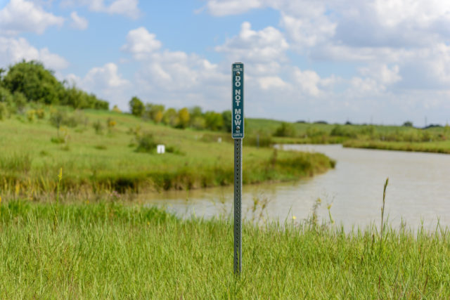
Willow Waterhole represents what has become Harris County Flood Control District’s ideal detention basin, with wetland shelves, “no-mow” areas along the banks, sinuous trails, a native plant palette, reforestation that climbs the banks and into new upland plateaus, the creation of islands as bird habitat — but it revolutionized the concept of detention basin as park by infusing it with stewardship from a diverse network of local residents and neighborhood and environmental organizations, notably the Willow Waterhole Greenspace Conservancy, Brays Bayou Association, and Houston Audubon. An impassioned community base now sustains and programs Willow Waterhole all year, organizing cleanups, plantings, workshops, regular wildlife inventories, sporting events, and major annual gatherings including the Music Fest, now in its fourth year.
 Willow Waterhole. Photo: Peter Molick.
The result is a landscape that has quickly become an urban place, a hub of activity, and a model for other detention projects. You’ll find few parking spaces here, which is odd for a park in Houston, let alone one of 300 acres, but is a testament to how integrated it is with surrounding communities, just a walk or bike ride away.
Eric Leshinsky is Senior Associate at Asakura Robinson.
For further reading visit:
Mankad, Raj. "RDAgents Takes on Willow Waterhole." Cite. Fall 2010.
Official Website of Levitt Foundation
Hamilton, Ann. "We Just Needed Some Curly Engineers:" Terry Hershey in Her Own Words. OffCite.org. March 6, 2017.