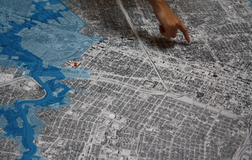


A 2,500 square-foot map of Houston flood zones in the University of Houston Gerald D. Hines College of Architecture atrium
A 2,500-square-foot map illustrating Houston’s flood zones was installed in the atrium of the Gerald D. Hines College of Architecture at the University of Houston on September 20th. In true Texas style, the map measures roughly 50 feet in both directions. Everyone who comes through the building is encouraged to stop for a moment and mark their house with a pin. The interactive result is a commentary on what connects us, water, and what divides us, the supremacy of our individual homes. The map will be exhibited until October 14th and is open to the public.
Some facts. Since the founding of Houston, flooding has been an invariable hazard. More and more pavement has made flooding even more frequent. A total of 614 square miles of Harris County, an area nearly equivalent to the size of Houston, are either in a floodway, 100-year flood plain, or 500-year flood plain. In all, this is 35 percent of all land area. In Houston nearly 500,000 people live in a flood zone.
According to the Harris County Flood Control District, a major flood occurs in our city on average every two years. During Tropical Storm Allison in 2001, 73,000 homes were flooded. Flooding isn’t constrained to good or bad neighborhoods. The flood waters don’t discriminate.
The project was imagined and executed by the Community Design Resource Center and supported by the UH College of Architecture. If you cannot visit the big printed map, the following link takes you to the Harris County Flood Control District's online map.